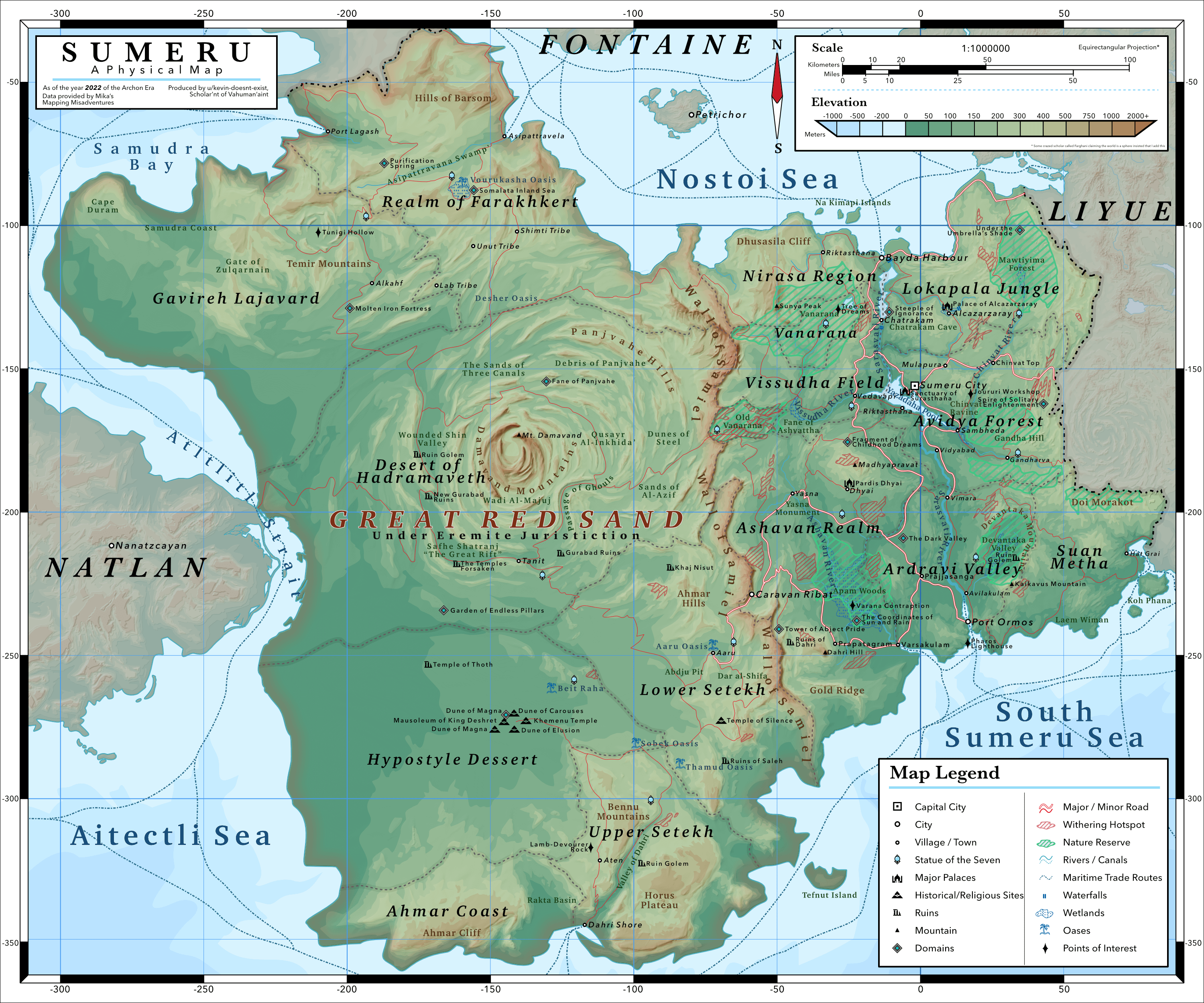
A fan-made physical map of Sumeru. This is the third in a series of maps of the nations of Teyvat. As with the other maps, this depicts Sumeru scaled up to 60x the in-game size based on the in-game clock, with some liberties taken in the physical geography to fit my realism constraints. Additional locations that don’t exist in the game have been added to depict a somewhat more realistic population distribution and to fill in the space, especially beyond the Paimon barrier (as of 6.4). Some locations that exist in the lore but not in the game’s main overworld map have also been added, such as the tribes featured in Nefer’s story quest, in somewhat reasonable locations. Various unnamed physical features have been given names as well.
For this map, I have also made a dem (digital elevation model) based off the heightmap shown here in order to produce a shaded relief layer to add. Hopefully it's worth the extra effort and roughly half a pen nib lol.
Also, I am even less acquainted with the languages depicted here (Arabic, Sanskrit, Egyptian, etc…) than I am with Chinese or Japanese (As in my maps of Liyue and Inazuma), so I really only hope that I haven’t inadvertently named something inappropriate.
On that note, there are also a few jokes here and there in the names as well, see if you can find them (assuming they are even intelligible)!
There is also an incongruity in the border between Liyue and Sumeru compared to my last map. I ran out of space on this map so I pushed the border in the southeast a little to the west.
Now onto my regularly scheduled rant about Teyvat’s scale, I really don’t know anymore. I am seriously considering just switching to a 20:1 scale or even 10:1 instead since it seems to line up better with travel times described in the game lately. For example, during the 6.2 main event Snowblazers’ Snowbound Journey, if you checked the in-game clock in between travelling to and from Dragonspine and Mondstadt, you have dinner in Mondstadt until 5pm, and then you’re in dragonspine and listening to Minnie argue with her parents by 6pm. With normal walking speed, that’s 4km at most, which implies that the true scale is about 5x the in-games scale. I had timed travelling from Mondstadt with Mualani, Chasca, and Iansan with Anemo resonance, and that still took about 2 hours of in-game time, which means that the in-game clock is not always a good basis for measuring distances in-game.
And then of course there’s the Traveller’s “short night walk” in 6.0 where they go from Nashatown to Hiisi island, go through all those Columbina shenanigans, and return in time for a good night’s sleep. Perhaps the teleport waypoints are canon, cool. But then the Traveler, on the day of their arrival in Nod-Krai, still had to travel from Nashatown to the Clink-Clank Krumkake Craftshop, hang out with Aino and Ineffa, continue on the the Frostmoon Scions and explore the area all within a single day before any of those waypoints are activated. That’s like an 80+km journey if the 60x scale is to be believed. Something at a 20x scale or smaller would be much more appropriate to describe this.
Moreover, I had tried putting my height map in blender and frankly, the terrain as shown here just looks much better at a 20x scale, and I’ve actually already designed the existing part of Natlan with said scale in mind, so I am seriously considering changing the scale of all my maps.
But then if said 20x or less scale is to be believed, for Teyvat to look as shown from the moon in 6.3, it would need to be so small as a planet it wouldn't even be a planet anymore, it would be an asteroid. Or maybe this won’t be too bad? Teyvat would look kinda like the Dres in KSP, and be similarly lumpy. Accepting this scale would also throw into the ditch any semblance of realism in terms of farmland necessary to sustain a reasonable population. And of course, the descriptions of distances from other quests disagree and imply a much larger scale as well (i.e. the Chasm AQ, Zhongli SQ, etc…). Of course, the map might just look really wonky compared to how it actually is, but if I go that route it won’t even look like Teyvat anymore.
Idk, Teyvat has its own laws I guess. O Primordial One, make this all consistent and I shall sing your praises so fervently that even Dawit’s lore videos will pale in comparison.
rW0HgFyxoJhYka2026-02-01 00:40
I mean according to this map, Traveler runs at around 1km a second.
BleedingUranium2026-02-01 01:37
Yeah, Teyvat is *significantly* more than 60 times larger in terms of canon scale. I've seen a few people use this "time is 60x faster, therefore size must be too"... which is not a leap of logic that makes any sense; time and space are not linked linearly in this way, like, *at all*.
Time is 60x because there are 60 seconds in a minute, and 60 minutes in an hour, thus moving one to the other feels intuitive and natural. Similarly, a 24-minute day (again, mirroring 24 hours) is an excellent amount of time for players to meaningfully experience the day/night cycle in a gameplay sense. Especially for a game where people may often only play for half an hour or so at a time.
None of this logic carries over to size scaling.
 
Given the recent from-orbit view we finally got, as well as a rare piece of dialogue which actually references a distance, Teyvat is likely to be canonically around 200 to 300 times larger than its in-game scale.
[I'll copy over a post I wrote recently:](https://old.reddit.com/r/Genshin_Impact/comments/1qd84ox/confirmation_that_it_is_indeed_a_globe/nzoozuu/)
 
Doing a quick check (with quest distances I happen to have available), the in-game distance from Mondstadt City (Adventurer's Guild) to Caravan Ribat, both of which we can see in this shot, is 6.1km. Someone good with math and measuring should be able to work out the diameter (in "fake" distance) of the planet from that alone.
One of the longest distances would be Mondstadt City to the docks at the south end of the holiday resort in Natlan, which is 14.7km.
 
Using the very accurate eyeballing and fingers-over-the-screen method, the planet is maybe somewhere around... 40 kilometres in diameter?
 
As for actual canon scale, we very rarely get any meaningful info, but there is one I know of for sure. In [Perilous Trail](https://genshin-impact.fandom.com/wiki/End_of_the_Line_(Quest\)), Bosacius says that they're to "hold the line at 100 kilometres outside The Chasm at all costs!".
Meaning 100km is sufficient distance to at minimum protect Liyue Harbour, and probably more so keep the threat contained to the Chasm area (so quite a lot more than 100).
 
The in-game distance from the entrance (as in, where the path enters from the east) of the Chasm area to that big square where the Rite of Descension was held is pretty much exactly 1km; if we measure from the centre of the Chasm it's about 1.5km.
Meaning if the canon scale was a whole 100x larger, that would still *barely* work for the "100km" dialogue, and even then only if we measure from the centre of the Chasm and assume they were holding "not far from Liyue Harbour" rather than "containing things to the Chasm area" (the latter making more sense in context).
 
So it's likely *more* than 100x larger, probably 200x or 300x larger, roughly speaking.
These would make the "3km" between Mondstadt City and Liyue Harbour into 600km/900km respectively, while the "5km" east-west width of Inazuma would be 1000km/1500km (real Japan is about 1900km).
 
If we were to *assume* "40km" planet diameter and 300x scale, that would be 12000km, almost ***exactly*** the same size as Earth; 200x would give us 8000km, two-thirds the size.
Organic-Army-90462026-02-01 02:57
teyvat would look like what from KSP? pretty sure that’s just a fan-made object /s
Strategicfaceroll2026-01-31 14:05
Nice work on this project! What software do you use to produce this? And also would you ever consider making an Expected vs Observed climate map for Teyvat? It would be pretty neat to see exactly how much the celestial nails have devastated the regions’s systems and what it may have looked like.
There’s also the matter of what is north/south but once the final (hopefully) nation is released we’ll have a clearer picture. Again, great work on the details!
kevin-doesnt-exist2026-01-31 14:30
Everything was done in Affinity Designer 2 and Gimp. I’ve already run a quick climate simulation on Teyvat using a few wrong assumptions. Now that we’ve seen Teyvat from space, I can make a more global map, and I’ll probably run another simulation after we get more information of what Snezhnaya will look like. What I can say based off of some educated guessing though, is that Teyvat seems to care very little about the natural dynamics of climate - nail or otherwise.
No-Construction-91192026-01-31 14:35
OP, a silly question from a non-expert 🙋♂️:
Why is the desert so green?
kevin-doesnt-exist2026-01-31 14:37
The colors represent elevation above sea level, not vegetation.
fubukishirou072026-01-31 11:01
Wow the celestial nail really screw over sumeru since almost half if not more of its land was turned into a desolate desert
Z000Burst2026-01-31 12:46
and people still poke Abyss stuff so that it can escape and eat their face
Zrva_V32026-01-31 13:10
I mean we don't know if the HP is really justified in casting down the nails. It might very well be a severe overreaction. Moon Goddesses seem to think so. Then again HP knows way more about the Abyss than them.
Great-Background15872026-01-31 14:42
Didn't Apep said she was nail because Abyss corruption and she undeniable HP hater .
and I think Kukulan also was said something slimier.
Costyn172026-02-01 02:21
The same Moon Goddesses that were imprisoned by the Abyssal Nibelung?
Also, remember how Sonnet became the Crimson Moon?
I don't think they understand what they're dealing with.
highlyregarded11552026-01-31 11:40
Fun fact: the Sumeru desert is actually BIGGER than it is in game, the ingame size is reduced compared to the canon for playability
Kaninkanan2026-01-31 12:19
It’s not exclusive to the desert
FennlyXerxich2026-01-31 15:20
This is true for just about every area, city, or even building in-game.
minimaltonic2026-01-31 11:49
Good stuff OP!! I really like how the topography looks, clearly based on in-game but they feel a bit more realistic now in your presentation. I also like the touches of showing the withering zones and nature reserves.
Biscotti-That2026-01-31 11:52
If I wanted to make maps like this (From a handdrawn map) which programs do you recomend?
And my biggest issue. How do you make "realistic" mountains? Cause one of the issues I need to deal is not only the mountain range, but the terrain elevation that will "ate" part of the mountain (Merge terrain and mountain to not them have a pit from were the mountain start at 0 range)
FlyingRencong2026-01-31 12:50
This guy mapping
Rex_Lapis_2026-01-31 13:10
Dunno man looks digital to me
pyre_light2026-01-31 15:00
Hypostyle Dessert?
GerKaiNeknete2026-01-31 17:18
As a cartographer myself i am enjoying this very much thank you!
casualgamerTX552026-01-31 17:43
Lovely. Sumeru is my favorite nation to explore. So vast. And I can't wait until Snezhnaya dwarfs it by a lot.
Ryuunoru2026-01-31 18:55
But it's digital
duecarion2026-01-31 20:39
Is ‘Hypostyle Dessert’ one of the jokes in the names you mentioned?
A really impressive map, well done and thank you for sharing!
kevin-doesnt-exist2026-01-31 20:43
Nope, that’s actually the name of the region in game, look it up. Most of the joke names were that a bunch of the names around the Bayda Harbor region translates to something along the lines of “Empty” or “Boring” (at least according to the dictionary I used).
sketchglitch2026-01-31 23:57
No, what people are meaning is that you made a mistake in spelling.
It's "Desert". "Dessert" is something sweet eaten after a meal!
kevin-doesnt-exist2026-02-01 00:03
Ooh that was unintentional. Actually you know what I totally intended that and this is exactly what I meant
Commentaires
For this map, I have also made a dem (digital elevation model) based off the heightmap shown here in order to produce a shaded relief layer to add. Hopefully it's worth the extra effort and roughly half a pen nib lol.
Also, I am even less acquainted with the languages depicted here (Arabic, Sanskrit, Egyptian, etc…) than I am with Chinese or Japanese (As in my maps of Liyue and Inazuma), so I really only hope that I haven’t inadvertently named something inappropriate.
On that note, there are also a few jokes here and there in the names as well, see if you can find them (assuming they are even intelligible)!
There is also an incongruity in the border between Liyue and Sumeru compared to my last map. I ran out of space on this map so I pushed the border in the southeast a little to the west.
Higher quality version: [https://imgur.com/a/oVcD286](https://imgur.com/a/oVcD286)
And then of course there’s the Traveller’s “short night walk” in 6.0 where they go from Nashatown to Hiisi island, go through all those Columbina shenanigans, and return in time for a good night’s sleep. Perhaps the teleport waypoints are canon, cool. But then the Traveler, on the day of their arrival in Nod-Krai, still had to travel from Nashatown to the Clink-Clank Krumkake Craftshop, hang out with Aino and Ineffa, continue on the the Frostmoon Scions and explore the area all within a single day before any of those waypoints are activated. That’s like an 80+km journey if the 60x scale is to be believed. Something at a 20x scale or smaller would be much more appropriate to describe this.
Moreover, I had tried putting my height map in blender and frankly, the terrain as shown here just looks much better at a 20x scale, and I’ve actually already designed the existing part of Natlan with said scale in mind, so I am seriously considering changing the scale of all my maps.
But then if said 20x or less scale is to be believed, for Teyvat to look as shown from the moon in 6.3, it would need to be so small as a planet it wouldn't even be a planet anymore, it would be an asteroid. Or maybe this won’t be too bad? Teyvat would look kinda like the Dres in KSP, and be similarly lumpy. Accepting this scale would also throw into the ditch any semblance of realism in terms of farmland necessary to sustain a reasonable population. And of course, the descriptions of distances from other quests disagree and imply a much larger scale as well (i.e. the Chasm AQ, Zhongli SQ, etc…). Of course, the map might just look really wonky compared to how it actually is, but if I go that route it won’t even look like Teyvat anymore.
Idk, Teyvat has its own laws I guess. O Primordial One, make this all consistent and I shall sing your praises so fervently that even Dawit’s lore videos will pale in comparison.
Time is 60x because there are 60 seconds in a minute, and 60 minutes in an hour, thus moving one to the other feels intuitive and natural. Similarly, a 24-minute day (again, mirroring 24 hours) is an excellent amount of time for players to meaningfully experience the day/night cycle in a gameplay sense. Especially for a game where people may often only play for half an hour or so at a time.
None of this logic carries over to size scaling.
 
Given the recent from-orbit view we finally got, as well as a rare piece of dialogue which actually references a distance, Teyvat is likely to be canonically around 200 to 300 times larger than its in-game scale.
[I'll copy over a post I wrote recently:](https://old.reddit.com/r/Genshin_Impact/comments/1qd84ox/confirmation_that_it_is_indeed_a_globe/nzoozuu/)
 
Doing a quick check (with quest distances I happen to have available), the in-game distance from Mondstadt City (Adventurer's Guild) to Caravan Ribat, both of which we can see in this shot, is 6.1km. Someone good with math and measuring should be able to work out the diameter (in "fake" distance) of the planet from that alone.
One of the longest distances would be Mondstadt City to the docks at the south end of the holiday resort in Natlan, which is 14.7km.
 
Using the very accurate eyeballing and fingers-over-the-screen method, the planet is maybe somewhere around... 40 kilometres in diameter?
 
As for actual canon scale, we very rarely get any meaningful info, but there is one I know of for sure. In [Perilous Trail](https://genshin-impact.fandom.com/wiki/End_of_the_Line_(Quest\)), Bosacius says that they're to "hold the line at 100 kilometres outside The Chasm at all costs!".
Meaning 100km is sufficient distance to at minimum protect Liyue Harbour, and probably more so keep the threat contained to the Chasm area (so quite a lot more than 100).
 
The in-game distance from the entrance (as in, where the path enters from the east) of the Chasm area to that big square where the Rite of Descension was held is pretty much exactly 1km; if we measure from the centre of the Chasm it's about 1.5km.
Meaning if the canon scale was a whole 100x larger, that would still *barely* work for the "100km" dialogue, and even then only if we measure from the centre of the Chasm and assume they were holding "not far from Liyue Harbour" rather than "containing things to the Chasm area" (the latter making more sense in context).
 
So it's likely *more* than 100x larger, probably 200x or 300x larger, roughly speaking.
These would make the "3km" between Mondstadt City and Liyue Harbour into 600km/900km respectively, while the "5km" east-west width of Inazuma would be 1000km/1500km (real Japan is about 1900km).
 
If we were to *assume* "40km" planet diameter and 300x scale, that would be 12000km, almost ***exactly*** the same size as Earth; 200x would give us 8000km, two-thirds the size.
There’s also the matter of what is north/south but once the final (hopefully) nation is released we’ll have a clearer picture. Again, great work on the details!
Why is the desert so green?
and I think Kukulan also was said something slimier.
Also, remember how Sonnet became the Crimson Moon?
I don't think they understand what they're dealing with.
And my biggest issue. How do you make "realistic" mountains? Cause one of the issues I need to deal is not only the mountain range, but the terrain elevation that will "ate" part of the mountain (Merge terrain and mountain to not them have a pit from were the mountain start at 0 range)
A really impressive map, well done and thank you for sharing!
It's "Desert". "Dessert" is something sweet eaten after a meal!